A Strenuous Yosemite Trio: Four Mile Trail + Panorama Trail + Half Dome


Trip at a Glance
| Distance | 25 miles |
| Elevation Gain | 7,200 feet |
| Elevation Range | 4,000 - 8,800 feet |
| Length | 2 days |
| Permit | Glacier Point to Little Yosemite Valley |
| Points of Interest | Union Point, Glacier Point, Illiouette Falls, Nevada Falls, Half Dome |
| Type | Point-to-point |
| Date of Report | May 15 - 16, 2021 |
The Route
| Day | Destination | Miles | Gain | Loss |
|---|---|---|---|---|
| 1 | Little Yosemite Valley via Four Mile Trail + Panorama Trail | 13 | 4400' | 2200' |
| 2 | Half Dome + return to Happy Isles via JMT | 12 | 2800' | 5000' |
Four Mile Trail (red) + Panorama Trail (blue) + Half Dome (purple) map. Click to view on AllTrails
Trip Overview
The stunning scenery as well as the intense mileage and elevation gain make this a killer overnight trip. Ever since I started backpacking in 2019, Yosemite has become my backyard. It’s an amazing backpacking destination and one of the closest to drive to from the Bay Area. In 2 days of backpacking, this route combines the best of Yosemite Valley’s South Rim: Glacier Point, Panorama Trail, Half Dome, Nevada Falls, and the Mist Trail. This was my second time climbing Half Dome in the off-season when the cables are down. (Read more about the climbing gear we used in my first blog post about Half Dome.)
The idea actually began as a pretty leisurely itinerary: drive to Glacier Point, take the Panorama Trail to Little Yosemite Valley, then hike back down to Happy Isles. We would park a car at each trailhead and shuttle between them. Then we added on Half Dome. My friends hadn’t done Half Dome before, and we didn’t need permits early season while the cables were down. Then we realized that shuttling ourselves from Happy Isles to Glacier Point would take over an hour, or over 2 hours total, so we added on the Four Mile Trail. The original plan was too “easy” anyway and the elevation gain would be “good for training”.
Parking
Parking was a nightmare.
Our group went in 2 separate cars, so we wanted to park one car at Happy Isles and one car at the Four Mile trailhead to save us around 2.5 miles of walking (the Yosemite Valley shuttle was not in operation in 2021 because of COVID) . At Happy Isles, there is parking along Happy Isles Road, at the Yosemite Trailhead Parking, and at Curry Village. We didn’t try the trailhead parking because it’s small, and we circled Curry Village for a while (competing with countless other cars) before we could find parking for the first car.
After we got into the second car, traffic made it take a while to get to the Four Mile Trailhead. There was no parking lot near the trailhead, and Sentinel Beach parking is day use only, so we had to circle the valley a second time. We considered parking on Northside drive at the Yosemite Lodge or Yosemite Falls parking and taking the path that cuts across the valley, but we couldn’t find parking there either. We finally found one lone spot in a pull out on Southside Drive around 0.8 miles west of the trailhead.
Day 1: Four Mile Trail + Panorama Trail
Despite our valiant efforts to leave the Bay Area before sunrise and get an early start to our trip, we somehow arrived at the Four Mile Trailhead at 12:30 PM. Yosemite Valley is extremely busy in May, which means lots of people and lot of cars. On a busy weekend in May, it took us over 1.5 hours to find parking for 2 cars. We also listened to the rangers’ obligatory wilderness permit lecture, waited in long lines at the Yosemite general store for the inevitable last-minute gear, and filled our water and used the bathroom.
By the time we rolled into the trailhead, the sun was beating down high over our heads and we were not looking forward to the strenuous initial climb. The Four Mile Trail gains 3,300 vertical feet from the valley floor to Glacier Point in just over 4.5 miles. You can drive to Glacier Point in the summer when Glacier Point Road is open, but there’s definitely satisfaction in doing the work for the views. With a 25 pound pack on my back, the cardio was intense and my legs burned. The trail looked like it used to be paved, with alternating sections of gravel and broken pavement. We could see both upper and lower Yosemite Falls as we hiked higher and higher. The volume of the falls was at its peak in May, but the distance made the falls look miniature.
The upper part of the Four Mile Trail is often closed in the winter because the dropoffs become a lot steeper. After Union Point, the trail approaches a wide ledge and we were rewarded with unobstructed views of the valley for a short stretch.


Taking in the views at Union Point, the first named point of interest on the Four Mile Trail

Approaching the ledge

Yosemite Falls viewed from the Four Mile Trail
A few hours later, we were at Glacier Point. It was a relief to know that most of the elevation gain was over, but we still had over 7 miles of hiking left and it was the time of day we usually stopped hiking to set up camp (nearly 5 PM). Glacier Point was bustling with day hikers and tourists with their cars, but we strolled past the trailhead with our heavy backpacks on like a badge of honor. Robinson was craving ice cream, and within the next 5 minutes he was actually eating ice cream. The Glacier Point gift shop sold it (not often that ice cream wishes get granted in the middle of backpacking). I bought a bottle of cold Gatorade and in that moment it tasted way better than water. Then we headed out on the Panorama Trail.

Glacier Point sits directly opposite of Half Dome and has one of the best views of Half Dome in the park
The trail system in Yosemite is surprisingly interconnected. The Panorama Trail connects Glacier Point to Nevada Falls and Little Yosemite Valley, which are more commonly accessed from the Happy Isles Trailhead. The Panorama Trail is often hiked as an out-and-back from Glacier Point to Illiouette Falls, but we used it to connect the first half of our trip to the second half.
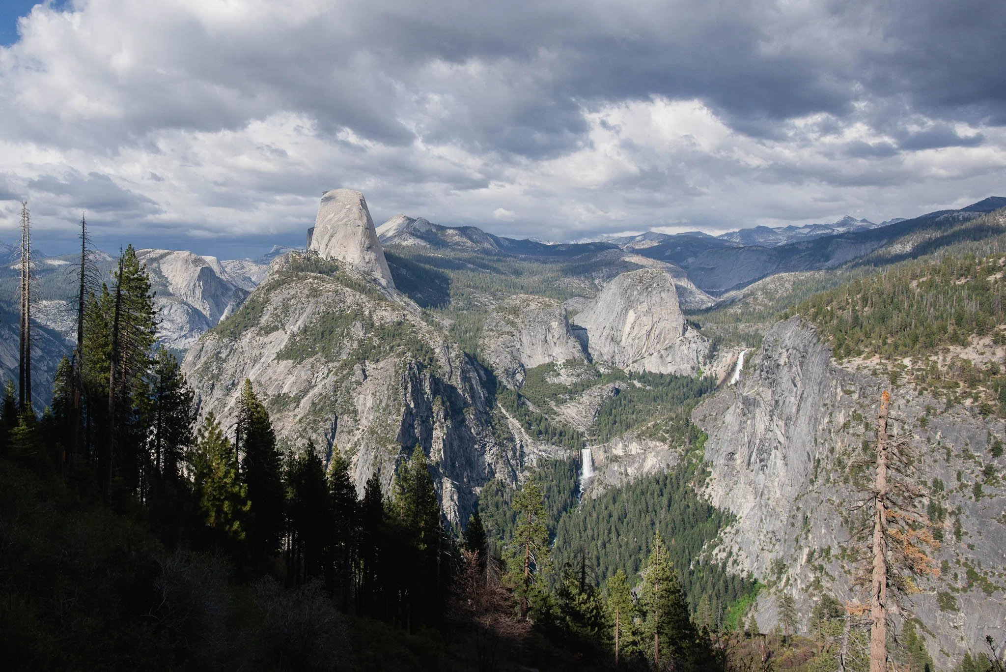
As we headed east on the Panorama Trail, the flat face of Half Dome shifted out of view and Half Dome became a full dome. We could see both Nevada Falls and Vernal Falls and the topography of the ground we’d be covering the next day.

Before descending to the creek and footbridge, we took a spur trail leading to the unofficial overlook for Illiouette Falls. Illiouette Falls is tucked away in a side canyon and well-hidden from the valley compared to Yosemite’s more famous sights. The overlook provides the only head-on look at the falls as you can’t hike to its base.

Illiouette Falls with Half Dome peeking out the back

The rushing waters of Illiouette Creek right before the falls
Once we crossed Illiouette Creek, the trail became uphill again. We had a nontrivial 800 feet of elevation gain to go. It doesn’t sound like much, but it was a physical and mental battle at 6 PM after all the elevation gain we did earlier that day. I braced myself for every uphill switchback. On the bright side, we were hiking during golden hour and the lighting made everything even more beautiful than it already was.
Fortunately, we found a beautiful vista point that broke up the ascent. There was an unlabelled spur trail around half a mile after we left the creek. On AllTrails it looked like it led to Panorama Point. The first part of the trail was overgrown with bushes. Half of our group all but collapsed in the first clearing we came to and refused to walk any further, but the few more minutes to the viewpoint were well worth it. There were dramatic drop-offs and views of Half Dome and the surrounding valley. We weren’t exactly doing well on time (it was around 6:30 PM at this point), but we took a rather generous break here to soak in the views and refuel on snacks.

Panorama Point views


As we got closer to Nevada Falls, there was a break in the trees and we could see three distinct humps: Liberty Cap, Mount Broderick, and Half Dome, all looking very golden in the sunset light. By the time we got to the Nevada Falls Bridge, the sunlight had mostly disappeared. The Nevada Falls area, usually packed with day hikers picnicking around the top of the falls, was completely empty. We were the only ones standing on the bridge, watching the whitewater tumble over the cliff. The sky had just a hint of pink. We put our headlamps on for the last stretch of hiking.

Finally done with the uphill

It’s a family picture! From left to right: Half Dome, Mount Broderick, Liberty Cap

Nevada Falls footbridge and Liberty Cap in the background

In May all the creeks and waterfalls are at full volume
It was a little daunting trying to find a campsite at Little Yosemite Valley in the dark. Everyone else had long settled into their campsites. We couldn’t tell where we were going or if we were walking through someone else’s campsite. Fortunately there were still enough spots and an empty bear box for us to put our food in.
Set up camp, filter water, cook, eat, sleep. It had been a loong day, and we had the uncertainty of a thunderstorm forecast looming over our heads. We planned to wake up at 4:30 AM the next morning so that we could summit Half Dome and make it back down before rain or thunder came in the PM.
Day 2: Half Dome
The pre-sunrise alarms never get easier. I took a sleepy peek outside and I could see stars—clear skies. We were on for Half Dome.
It took us around 2 hours to get to the base of subdome. When the Half Dome cables are up, a permit is required to venture beyond the base of subdome. I remembered the portion of the trail to subdome being a real slog in my first trip in 2019, especially when you can’t see where you’re going in the dark. It’s only 3 miles, but the uphill is steady and the view is mostly obscured by trees. When we reached the sandy plateau right before subdome, we got our first views of the morning. Half Dome towered high above the trees and the Clark Range was an iconic panorama in the distance.


Subdome is so steep that it looks vertical. It was impossible to imagine how a trail could possibly take us up to the cables. The answer? Tons and tons of stairs. Some of the steps were taller than knee height. The last section had no stairs and was just a trust exercise with our shoe soles. The granite itself was grippy enough, but the occasional gravel that had accumulated on the surface of the rock was the ultimate slip hazard on the hike back.

Can you tell how steep this is?

Stairs and more stairs

The final part of subdome doesn’t even bother with stairs. It can be quite slippery here which is why you don’t attempt subdome if it is raining!
We were the first group at the cables that day. It was surreal having the place to ourselves. We unpacked and geared up with a harness, gloves, and 2 prusik loops with carabiners. Bruce held out a hiking pole for us and we all re-practiced tying our knots in an impromptu climbing workshop.


The cables are the most infamous part of the Half Dome hike. It’s what tens of thousands of people are entering the Half Dome permit lottery for every year. You’re climbing up a giant, steep rock, completely exposed, thousands of feet above everything around you with views in every direction. Not to mention the adrenaline-inducing possibility of slipping and falling to your death.
We went up in pairs, side by side on the two cables. These cables are propped up by poles during the hiking season and wood slats are inserted in intervals for people to stand and rest on. All that is left during the off-season is two cables bolted into the rock. Even just lifting the cables to hold on to them was strenuous. I could only take maybe 10 or 15 steps at a time until my hands started burning and my heart raced. Then I would lean back on my rope and gaze at the view. The first time I did Half Dome two years ago, I had stashed away my camera during this portion of the hike since I thought I would be too afraid to use it. This time I had my camera out and was able to get way more shots of this section.

Going up in pairs so we could check each other’s knots


The sky was clear above our heads, but a gray sheet of clouds sat on the distant horizon. Every time I took a break the clouds looked a little closer. The cables took us a long time since we had to untie and retie both of our prusik loops to get around the cable bolts. Some places were so steep that it was hard to stay standing while tying the knots so we sat or knelt on the slanting rock. As we rounded the top of the dome, the slope flattened out and we didn’t tie on to the cable anymore. Fluffy, voluminous clouds had formed all around us by then. They definitely looked like rain clouds.


The top of Half Dome is surprisingly huge and flat and there’s a lot of room to walk around and explore. We took some photos on The Visor, which is a slab of slightly overhanging rock. If you’re brave enough, you can sit on the edge and look straight down into Yosemite Valley. I could have lain on the top of Half Dome all day but we had to get going to beat the rain. The way down was familiar but still tiring. We relied on our arms to lower ourselves step by step, and on the steeper sections our arms took a lot of the weight.


The approaching storm and fast-moving clouds created a lot of drama in these photos
When we were almost back to Little Yosemite Valley, we couldn’t even see the top of Half Dome anymore. It was covered by clouds. I couldn’t imagine how scary it would be to stuck up there in low visibility. The sky was dark and gloomy as we packed up our camp and headed back to Happy Isles.
It was 4.5 miles from Little Yosemite Valley to Happy Isles and another 1 mile walk to where our car was parked at Curry Village. We decided to take the John Muir Trail back rather than the Mist Trail because (1) we did not want to get wet and (2) none of us had taken that trail before. It’s slightly longer than the Mist Trail so I was expecting it to be less steep, but those switchbacks were endless. The fact that it was downhill didn’t make it any better. The uneven trail was a mix of crumbling concrete and gravel. My knees ached with every step and I almost rolled my ankles multiple times.

John Muir Trail views. Half Dome is obscured by clouds in the background
In the last 2 miles it began to rain. We all were fortunately prepared with rain jackets, but the hike became an even more dreary trudge until we finally reached the Curry Village parking lot. It was already past 7 pm. As we were loading the car, the rain suddenly stopped. Sunlight broke through the clouds and a faint rainbow arced across Half Dome. We were treated to some amazing views as we made our way back around the valley to our other car. At one pullout, we could see Half Dome gleaming in the golden light. We had seen a full spectrum of weather that day from clear skies to rain to rainbows, but somehow the conditions worked out perfectly in our favor.

