Backpacking the Grand Canyon of the Tuolumne in Yosemite


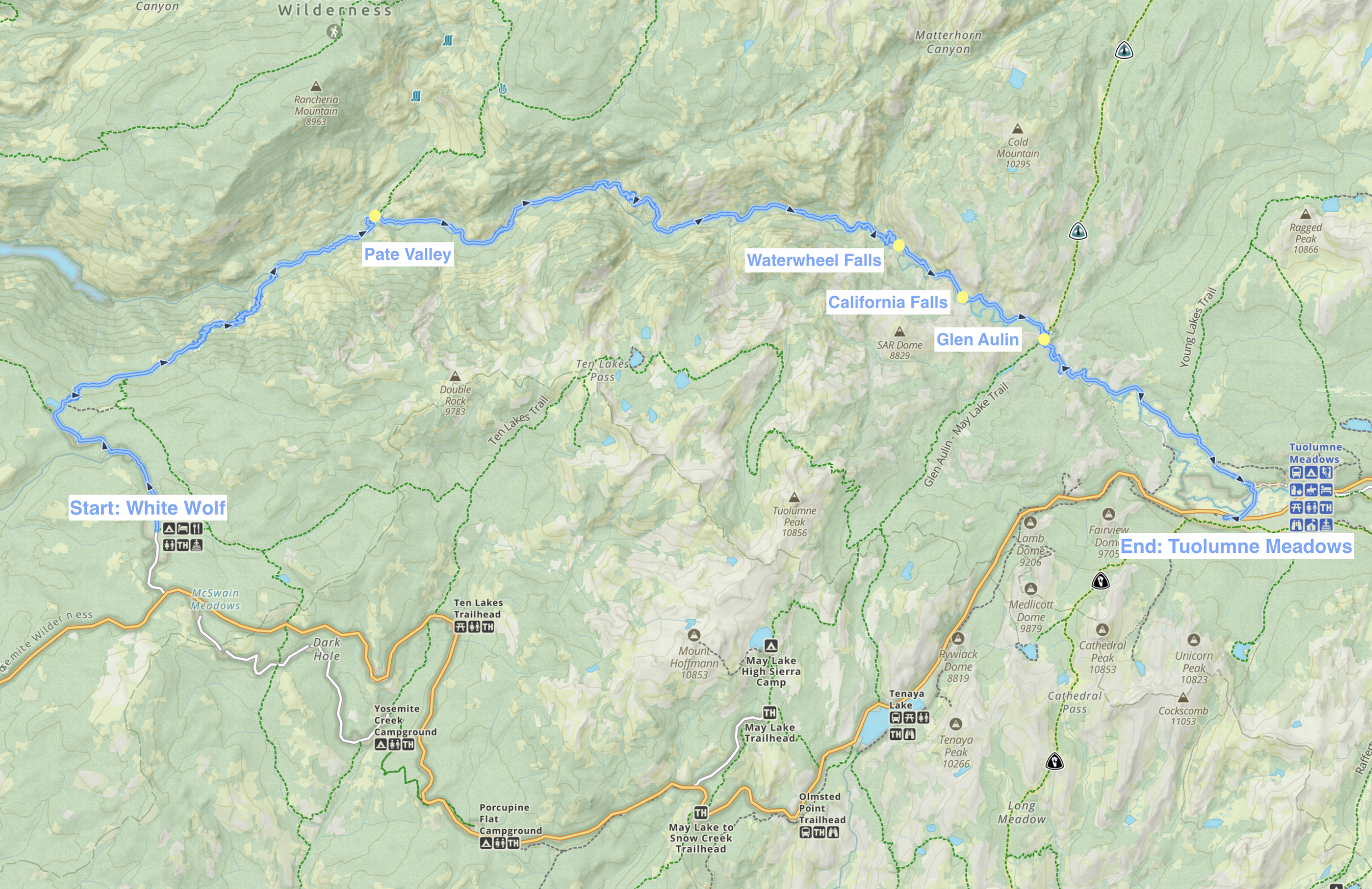
Grand Canyon of the Tuolumne is the lesser known cousin of the world-renowned Yosemite Valley. It’s far from the crowds and traffic, and not any less spectacular. The 30-mile trail follows the Tuolumne River through the canyon and takes 3-4 days to complete. The journey shows off the many personalities of the Tuolumne River from calm, emerald pools to whitewater rapids and thunderous waterfalls. It makes you feel small as you hike beneath towering canyon walls sculpted by the river’s powerful flow. This is Sierra backpacking at its finest, and incredibly underrated.
To enjoy the waterfalls at their peak, plan to visit as soon as Tioga Road opens (usually May-June). The waterfalls dwindle as the season progresses, but this reveals swimming holes and natural water slides that are great for cooling off in.
We backpacked the trail over Labor Day weekend in September 2023 expecting the latter, but it was an unusually cold Labor Day and an unusually high-flow year. The waterfalls were still roaring thanks to the record-breaking snowpack of the previous winter.
Trip at a Glance
| Distance | 29.5 miles |
| Elevation Gain | 5,760 feet |
| Elevation Range | 4,229 - 8,654 feet |
| Length | 3 days |
| Permit | White Wolf->Pate Valley |
| Trailhead | White Wolf |
| Highlights | Pate Valley, Waterwheel Falls, California Falls, Glen Aulin, LeConte Falls |
| Type | Point-to-point |
| Date of Report | Sep 2-4, 2023 |
See route on AllTrails
The Itinerary
A Short and Sweet Guide
This is a point-to-point hike between White Wolf trailhead and Tuolumne Meadows. It can be done in either direction.
Transportation between the Trailheads
There are two shuttles that run between the White Wolf and Tuolumne Meadows stops. They are only operational during the summer season (exact dates vary depending on Tioga Road’s opening date).
Alternatively, if your group has 2 cars, then you can do the shuttling yourself.
Making It A Loop
If you want to eliminate the need for shuttling, you can make the trail a loop via Ten Lakes Pass and the Glen-Aulin - May Lake trail. This will take 5-6 days. Here is a link to someone else’s trip report for this loop version.
Permits
Permits are required. Reserve permits in advance at Recreation.gov. Note: the permits for each direction are different.
Which Direction is Better?
White Wolf -> Tuolumne Meadows
The scenery gets better as you go.
Permit name: White Wolf -> Pate Valley if you’re camping past Harden Lake the first night, or White Wolf -> Smith Valley if you’re camping at Harden Lake (2.8 miles).
Tuolumne Meadows -> White Wolf
Downhill for most of the trip. Steep uphill on the last day.
It’s probably easier to hitchhike from White Wolf to Tuolumne Meadows than the other way around, so this direction will allow you to end at your car.
Permit name: Glen Aulin -> Cold Canyon/Waterwheel if you're camping past Glen Aulin High Sierra Camp the first night or Glen Aulin if you’re camping at Glen Aulin (5.3 miles).
Day 1: White Wolf to Pate Valley
Our Tuolumne Meadows to White Wolf YARTS bus was scheduled at 10:20 AM. We were doing the whole drive from the Bay Area that morning, so my alarm was set for a very painful 4 am. I convened with my group in Oakland and we left at 5 am. We drove several hours in the dark.
After one bathroom stop, the line at the Yosemite entrance gate, and picking up permits from the Tuolumne Visitor Center, we just barely made it to the bus stop at 10:20 AM. Fortunately, and I don't know if this is the norm, the bus was 20 minutes late. We got to catch our breath and organize our packs better while we waited.
The YARTS bus was surprisingly comfortable and very quiet because almost everyone was sleeping.
It was an overcast and breezy day. The temperature was much cooler than what I would have expected for a typical Labor Day weekend in the Sierra. We set out from White Wolf a bit after 12 PM. After hiking for 15 minutes, we realized we were on the wrong trail. Even though the trail was marked on the map and was eventually supposed to merge with the right one, it was becoming progressively more faint and overgrown. We decided to turn back to be safe.
The right trail starts out on a wide dirt road before narrowing into single-track. Before long, we were on a steep descent into the Grand Canyon of the Tuolumne. And the name really does not oversell it. It was an incredible birds eye view into the canyon that we would be hiking through the bottom of the next day.
We encountered some brief but heavy rain in the afternoon, which made for moody clouds and lighting during our hike down. One of my favorite views of the trip was of Hetch Hetchy Reservoir while the rain was passing over us.
The trail was pretty forested at first, but we got a few glimpses of the canyon
Hetch Hetchy Reservoir. You’ll see it between the trees a few times before this more open viewpoint. It’s labelled on AllTrails at mile 5.5.
Rain clouds passing over the valley
This section of the descent had incredible canyon views made even more stunning by the faint double rainbow
Looking towards the bottom of the canyon, which still felt quite far
Nearing Pate Valley, almost 4000 ft of descent later
A mossy pond near Pate Valley
There is no sign indicating the start or end of Pate Valley, but we were finally walking on flat ground so we figured we would come across some campsites soon.
We stopped at the first clearing in the woods large enough to hold our tents and decided to set up camp since the daylight was disappearing quickly. The nicer, larger spots are after the Pate Valley bridge, which we would cross the next morning.
Day 2: Pate Valley to Waterwheel Falls
We awoke to a steady drizzle at 6:30 AM. The forest was dark and wet. The first thing I had to do was put on my rain jacket to get food from the bear can. I ate muesli in my tent while I tried to pack up as much as I could without having to go outside again. Finally, we packed the tent, which was not easy to do in the rain. The inner tent went inside my pack and the dripping rain fly I strapped to the outside of my pack.
For the next few hours, we gradually the canyon. Sometimes we were in the trees, but other times we had views of the clear river, or the staggering canyon walls decorated with low, wispy clouds. The moody, muted colors made the scene reminiscent of a Chinese landscape watercolor painting.
Slower section of the river near Pate Valley
This unnamed cascade is right next to the trail.
It rained on and off the whole day, so nothing ever had the chance to dry. My pants were stuck to my upper thighs. My shell was wetting out and I was feeling damp from my trapped sweat. The back of my pants was completely soaked. I was confused by this one. My theory was that my rain fly had been dripping water between my pack and my back, and my pants were catching the excess. Anyway, it was a far cry from the Grand Canyon of the Tuolumne experience described by other trip reports, which involves taking every possible chance to jump into the river because it is torturously hot. So maybe we had it good!
A great swim spot in better weather! This waterfall is near where Register Creek merges with the Tuolumne River at Muir Gorge.
The steepest part of the day was the short section of switchbacks past Muir Gorge. The switchbacks climbed away from the river for almost 1,000 feet. At the top, we had a sweeping view of the canyon. This could have been a nice lunch spot, but it was too exposed and it looked like it could start raining any minute. So with growling stomachs, we kept going until we were back in the trees.
Climbing away from Muir Gorge
Normally, you’d have views of Colby Mountain and Grand Mountain here, but low clouds hid the tops of the mountains.
Heading back down to the river.
We ate lunch under tree cover and then ended our day with a final set of switchbacks to the top of Waterwheel Falls. One member of our group was not feeling well, so our pace was quite slow by this point. The light was almost gone when Waterwheel Falls started coming into view on our right. I'm not sure if there are any suitable campsites here, since we decided that right next to the trail would have to do.
Before we retreated into our tents for the night, I noticed that the sky was full of stars. It looked like the rainy weather had passed and I was hopeful we would see sun the next day.
Waterwheel Falls on our right
View of the canyon from Waterwheel Falls
Day 3: Waterwheel Falls to Tuolumne Meadows
We woke up to a bluebird day. We could clearly see the canyon that was obscured by clouds before. I almost missed the mystery of the clouds to be honest.
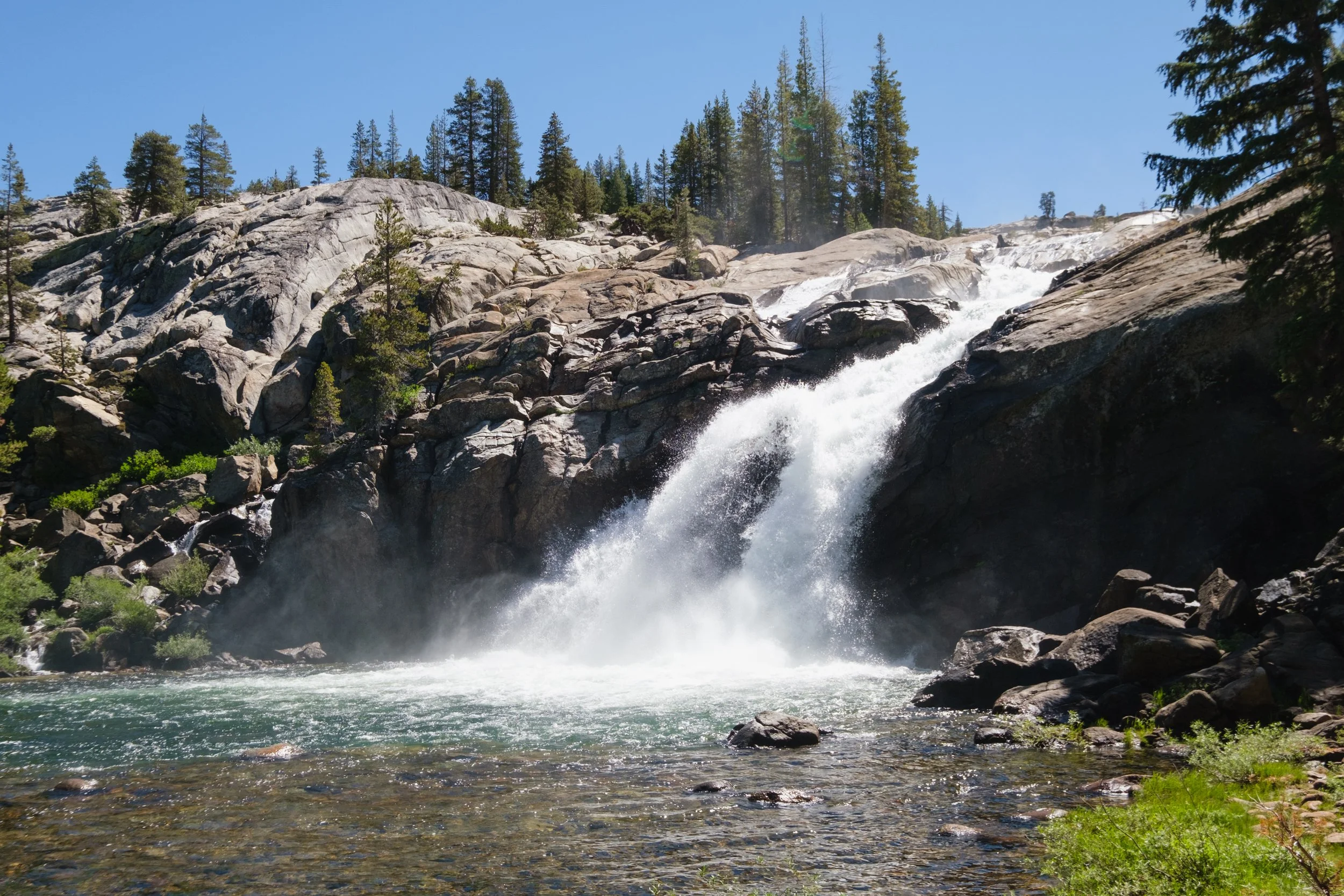
After we packed up camp, we explored the area around Waterwheel Falls. I thought it was interesting how the waterfall flowed over the surface of the rock and not in a riverbank or any sort of depression. This made it easy to walk so close to the river that the frothing edges lapped at our feet. The water roared in front of us, and leapt upwards when it slammed into ledges to create the "water wheels" that the waterfall is named for.
Standing near the top of Waterwheel Falls
The water wheel from afar. I didn’t have time to get a good photo with it because it was a steep hike down and back up.
The named waterfalls to look out for after Waterwheel Falls are LeConte Falls and California Falls. I'm not sure how this happened, but we completely missed LeConte Falls. Based on other trip reports, it looks like it's a bit off the trail and we missed the turnoff for the short side trail to it. We were a considerable distance past LeConte Falls by the time I was trying to look for it, which led us to stumble across a spectacular waterfall that was definitely not LeConte Falls. This unnamed waterfall was also on a side trail, and it was one of the highlights of our trip.
The unnamed waterfall after LeConte Falls
The same spot from a different angle
Day 3 was waterfall after waterfall. There were so many of them that we couldn't tell when we were at one of the "official" waterfalls or just an unnamed one. When every steeper section turns into a waterfall, how can you really name them all? Plus, a lot of the waterfalls we were seeing were probably unnamed because they might not exist when the river's flow was lower.
Next was California Falls. It was hard to tell when we were at California Falls because there are so many photos of it that look different from each other. This seems to be because California Falls is actually a long sequence of waterfalls. The granite around the waterfall is easily walkable, and it’s worth the time to explore and appreciate the waterfall from all of its sections. We saw several well-cleared and sheltered flat sites around here, so California Falls would make for a good night 2 camp.
California Falls
Another waterfall. Or still California Falls?
More California Falls??
The impressive granite features surrounding California Falls
A swimming hole that I did not swim in. I actually did not get in the water at all on this trip, so I really need to come back!
After California Falls, the steepest climbing is over. So are most of the waterfalls. The trail still follows the river, but it is calm as it winds through Glen Aulin meadow to Glen Aulin High Sierra Camp. Glen Aulin is an official backpackers campground in a huge, flat wooded area. I think it wasn't in operation when we were there though since the manmade structures like outhouses and bear boxes were locked up.
Leaving the camp, we merged on to the PCT. A short climb brought us to the last big waterfall of the trip, Tuolumne Falls.
Looking back towards Glen Aulin
White Cascade right next to the bridge at Glen Aulin High Sierra Camp
Tuolumne Falls
View from the PCT, looking back towards the Grand Canyon of the Tuolumne
The dramatic walls of the Grand Canyon of the Tuolumne were far behind us now, and it was a mostly flat hike back to the trailhead. As we neared Tuolumne Meadows, we caught glimpses of the pointy peaks of the Cathedral Range beyond the meadow. And we also saw a bear! This was my 5th year of hiking in Yosemite and the first Yosemite bear that I've seen.
Cathedral Range
A black bear near Tuolumne Meadows
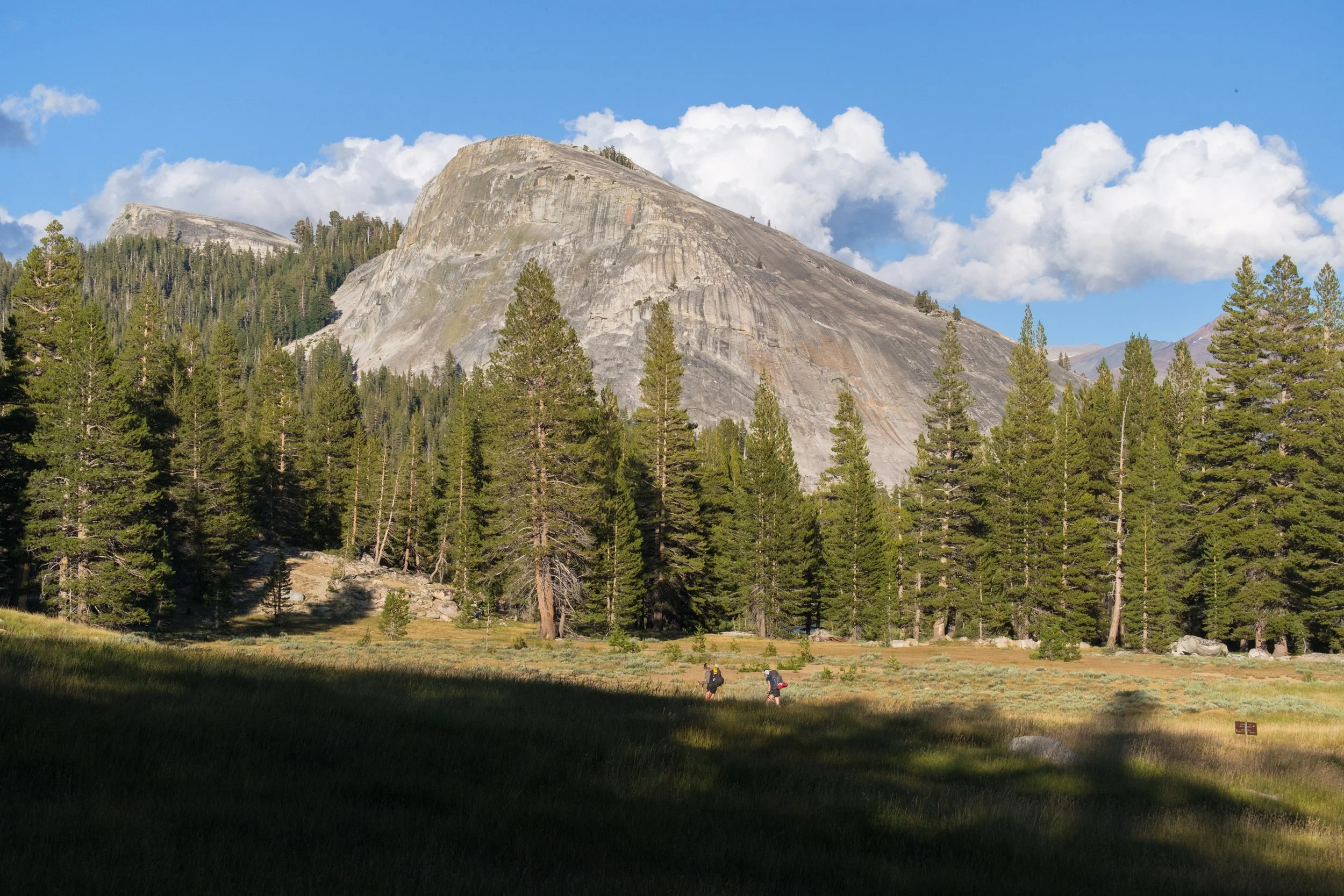
Backpackers headed past Lembert Dome


